
The Story of Ripon
The information shown on these pages has been reproduced from an article by Maurice H. Taylor, a local historian.
Introduction
Ripon is a market town of some 16,000 inhabitants and is situated on the western edge of the Vale of York about 4 miles west of what has been, at least since Roman times, the main north-south route on the eastern side of the Pennines, whose foothills start just west of the city.
It lies on the River Skell, just west of its confluence with the Ure, and is at the focus of five main roads – the A61 (north) to the A1 and Thirsk; the B6265 (east) to the AI, Boroughbridge and York; the A61 (south) to Harrogate and Leeds; the B6265 (west) to Pateley Bridge and Skipton; and the A6108 to Masham, Leybum and Wensleydale.
In the Beginning
Some 230 million years ago Ripon lay at the edge of a tropical sea. Quarry Moor formed the beach. When the upper rocks at Quarry Moor were formed the sea was beginning to dry up and become very salty. The crystals formed layers which eventually dissolved, the land above gave way and great holes formed. It is still happening today.
Much later the meltwater from the Wensleydale glacier came down Skeldale, scoured out the valley and left its debris in the plain below. Remnants survive in the mound at Ailcey Hill, for example.
To the north and east of Ripon, earthworks and henges (the biggest group in the country) indicate occupation from the megalithic and bronze age periods.
Two Roman roads pass within a few miles of Ripon and there is a tradition of a Roman ford about fifty yards below North Bridge. Some coins, pottery and a small funeral vase turned up in the 19th century. On the nearby moors two peat diggers unearthed the preserved body of a man wearing a toga. Two pigs of Roman lead were found. The remains of Roman buildings exist at Castle Dykes, Well, Sutton, Nutwith and Aldborough. Some mosaic tiling at St Mary Magdalen chapel is suggested as Roman. The crypt of the Cathedral, the oldest post-Roman vault to survive in England, contains re-used Roman stones and it is now suggested that the builders may conceivably have re-used a pre-existing Roman vault.
Following the River Ure, the Hrype tribe probably reached the Ripon area sometime in the sixth century to found a settlement close to its confluence with the River Skell. The town stands between 70 and 150 feet above sea level. The name “Ripon” comes from these northern European Angles.
About A.D.715 the settlement is called ‘(in)Hrypis’. Some 15 years later the Venerable Bede refers to ‘Inhrypum’. At other times it has been called Hrypsaetna, Onhripum, Rhypum, Hryppun, Hrypon, Rhypon, Ripum, Ripun, and of course, Rippon. The second ‘p’ disappeared around 1800 but both forms overlapped for a while.
The Hospital Chapels
Before the building of Archbishop Roger’s minster at least two of Ripon’s hospital chapels had been founded. They were placed close to the river crossings: St John’s, as one approaches the town to cross the Skell from the south at Bondgate, was established between 1109 and 1115; St Mary Magdalen’s, as one crosses the Ure, approaching the town from the north, shortly afterwards.
Each provided food and shelter for the poor and had a special ministry to travellers. St Mary’s, for a time, cared for lepers and blind priests: St John’s, for poor clerks keeping their schools at Ripon. These two chapels had become relatively wealthy by the 13th century – indeed at one point St Mary’s may have had as many as six chantry priests attached – and as a result suffered depredation from pluralist clergy masters.
The Administration
After the Norman Conquest to determine custom and practice the old Anglo-Saxon laws were formally written down. In Ripon’s case, the ink was hardly dry on the ‘Athelstan’ charter when it was presented in a lawsuit between the archbishop and the canons. The canons had successfully defended their rights before but in 1228, after producing another Athelstan charter, the jury again supported their position.
The wakemen, whose office may go back to Athelstan, were responsible to the Archbishop for arrangements within the town and for its security. The Wakeman could exact fines and was required to make compensation in the event of burglary during the hours of the watch. By the end of the 16th century, the overlapping jurisdictions of Archbishop, Chapter and Wakeman were no longer proving effective. Reforms were introduced in 1598 with a new, fourth, Town Book setting out duties, responsibilities and penalties.
Following the Reformation to 1834, Ripon was policed by parish constables, who operated under the magistrates and whose wages were sanctioned at the quarter sessions. From 1836-52 the council leased the building at the junction of Duck Hill and Kirkgate, as town house and police station.
They set up a watch committee and, in addition to the two night watchmen, appointed two police officers, the former parish constables.
The door at the foot of the steps on Duck Hill led to their lock-up, built in 1838. In March 1877, having been arrested for drunkenness and thrown into the lock-up, Richard Seaburgh, boiler-maker, set his bedding alight and suffocated. After this tragedy the city council bought No. 5, Kirkgate, adding four cells – the barred windows can be seen from Duck Hill. The ground floor housed the fire engine.
Town and City
Unusually, because it was not fully a borough, in 1295 Ripon sent two MPs to the Model Parliament and then sporadically afterwards until regular representation was established following the accession of Queen Mary in 1553. Ripon became a typical Rotten Borough.
As lords of the manor and founders of the burgages, Archbishops of York influenced the elections till the end of the 17th century when the Aislabies of Studley Royal took control of the voting rights by purchasing large numbers of the burgage properties. Ripon’s entitlement to be termed city is relatively modern, deriving from the creation of the diocese of Ripon in 1836 when the minster became the seat (cathedra) of the diocesan bishop. There is no record of the honour having been conferred earlier by Royal Proclamation . With local government re-organisation in 1974 Ripon lost its entitlement but as one of a group of historic towns, honorary city status was conferred by the Queen.
The 1379 poll tax returns included some 38 cloth-workers and 25 leather workers amongst the 583 tax-payers of Ripon, Bondgate and Aismunderby representing a 14th century population estimated at around 1200; it had risen only to 1700 by the 17th century.
Towards the end of 16th century plans were well advanced for a theological college in Ripon – a university of the North – on the 15th century Bedern (Old Deanery) site, but financial or other considerations persuaded James I, in 1604, to re-constitute the minster with a Dean and Chapter instead.
Through the good offices of Wakeman Hugh Ripley, the town also was granted a charter giving it borough status with a recorder, mayor and corporation and elevating the office of Wakeman to that of mayor. 1862 eventually brought higher education to Ripon with the establishment of a diocesan training college for women elementary school mistresses.
In 1713 plans were put in hand for a racecourse to be laid out on the High Common and races, one meeting a year, soon followed. Mrs Aislabie of Studley Royal was criticised for sponsoring possibly the earliest ladies= horse race in which ‘nine of that sex rid astride, dress’d in drawers, waistcoats and jockey caps, their shapes transparent, and a vast concourse to see them’. With the enclosure of the Common in 1826, racing had to stop. It re-started in 1837 with a two-day meeting on a new course north of the river Ure. In 1865 a course was laid out off Whitcliffe Lane, but that proved dangerous. Racing moved to Boroughbridge Road in 1900.
The Spa was Ripon’s early 20th century attempt to improve its economy. A sulphur spring was known in Stonebridgegate from 1760 (the capped well is close to the boundary between the Stonebridgegate gas holder site and Williamsons), but a scheme to bring sulphur water from Aldfield, discovered in 1698, to the fashionable Park Street area was preferred. In 1900 the Marquis of Ripon sold the Drill Field on Park Street for a pump room and pleasure gardens. Samuel Stead designed the art nouveau Spa Baths, of 1905. The Spa Hotel opened in 1909. Unfortunately the fashion for spa treatments had passed Ripon by and in 1947, the Ripon Spa scheme was abandoned.
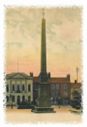
River crossings have always been important to Ripon. Tracks between the fords anticipated the later road system. Bridges followed: Bondgate Bridge and Hewick Bridge are first recorded in the 12th century. Ripon’s basic layout dates back well over a thousand years. Despite what the plaque on the obelisk says, in 1702, starting from a, 50 legacy to replace the old market cross the mayor, John Aislabie of Studley Royal, engaged architect Nicholas Hawksmoor (of Castle Howard fame) whose scheme for the market place echoed an entire Roman-style paved forum as well as providing a new pillory.
As a result Ripon acquired the earliest free-standing monumental obelisk in the country, Daniel Defoe described Ripon Market Square as ‘The finest and most beautiful square that is to be seen of its kind in England’. The obelisk was restored and remodelled in 1781, largely at the expense of William Aislabie, to commemorate his sixty years as the longest serving Member of Parliament.
Twenty years later William’s daughter, Mrs Elizabeth Allanson, commissioned the fashionable architect, James Wyatt, to build the Assembly Rooms, now the Town Hall. As well as meeting for cards at the Assembly, from 1792, in the season, the local gentry had been able to enjoy the new theatre, purpose-built, on the corner of Park Street and Firby Lane.
The Ripon Canal opened in 1773 to link the city to the navigable stretch of the River Ure, and via the Ouse to the Humber. Barges took butter, cheese, lead and bricks and returned with coal, but the Ripon Navigation soon lost money. Its death knell came with the Leeds and Thirsk Railway in 1848, which could bring coal from the Durham coalfields cheaper and quicker than the canal could from south Yorkshire.
To accommodate its growth the city spread north (to the old railway); south on the first world war Army Camp site; west – encouraged by the Studley influence and the Army Camp; and east – the former Varnish Works and Canal warehouses – where light industrial development has mostly occurred, and which the opening of the eastern by-pass in 1996 is likely to reinforce.
Soldiers had been billeted at Ripon on and off for over a hundred years before the outbreak of the First World War and the old racecourse at Hell Wath had been used for Territorial Army training for a number of years. To try to boost the economy, the Corporation was already negotiating for a permanent Army Camp so when war broke out Ripon was well placed for the construction of what became one of the largest army camps in the country accommodating some 30,000 soldiers, completely dominating the city. Captain Wilfred Owen, the poet, was posted to Ripon where some of his most important war poems were written in rooms taken for the purpose in Borrage Lane. After the war the camp reduced in size, particularly to the south. It came into prominence again during the 1939-46 war. Claro and Deverall barracks presently house the Royal Engineers.